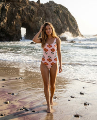
Pfeiffer Beach, Big Sur | Top 100 Bikini Destinations

BIG SUR, CALIFORNIA / USA
Where the surf meets the arch,
Pfeiffer Beach.
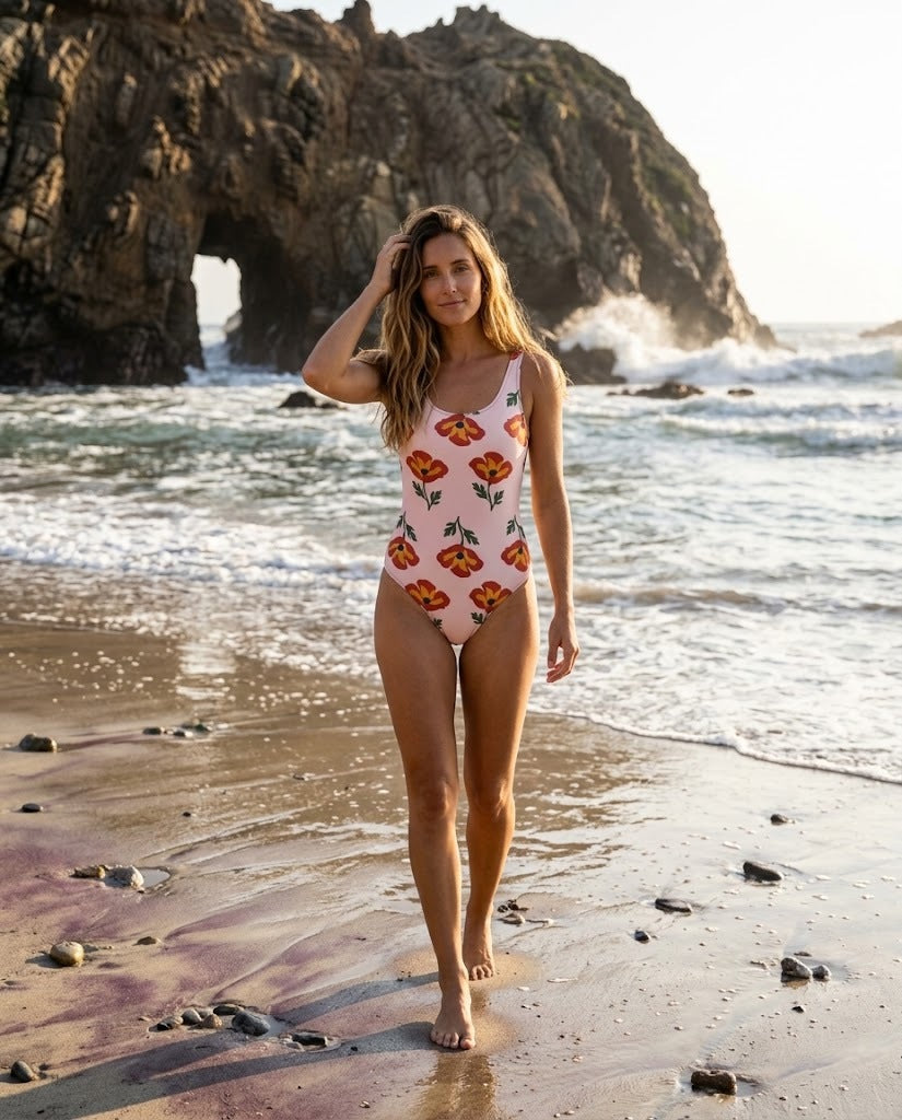
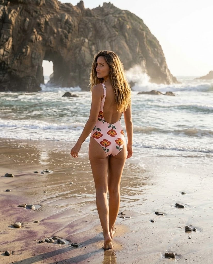
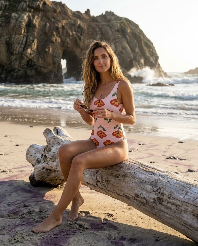
A Big Sur day of purple-streaked sand, Keyhole Arch, and cold Pacific surf, with a warm layer for the wind.
Plan your beach day ↘TOP 100 BIKINI DESTINATIONS / BIG SUR
At the end of a canyon road,
a beach for the light.
Pfeiffer Beach is a Los Padres National Forest day-use beach on the Big Sur coast, reached by a narrow canyon road off Highway 1.
Come for the rock stacks, the arch, and the sand streaked purple by minerals washed down from the hills. This is a beach for walking and photographs rather than swimming: the water is cold, and the Forest Service warns of rocks, strong currents, and rip currents. There is no food, drinking water, or restroom at the beach, so stock up in Big Sur Village first.
ON THE WORLD MAP
On California’s Big Sur coast.
Pfeiffer Beach, Big Sur, California

01 / GETTING THERE
Start in Monterey.

Driving Highway 1
Bixby Creek Bridge carrying Highway 1 along the Big Sur coast.
Photo: Thomson200 ↗ · CC0 ↗ · Display cropGet around Big Sur
A car is the practical way to link the beach, the state parks, and the restaurants along Highway 1. Fill the tank in Monterey or Carmel; fuel in Big Sur is limited and expensive. In late summer 2026 the Timber and Plaskett fires closed parts of Highway 1 and the national forest; all of the highway reopened in mid-September, but some trails remain closed.
At the gate
The day-use area opens from 9 a.m. to 8 p.m., with 65 parking spaces that are usually full on summer and holiday weekends. Arrive early, or come on a weekday. Forest Service site details ↗
02 / BEACH ESSENTIALS
Know before you go.
A wild Forest Service beach with a fee, a short path to the sand, and no services at all.
01 / HOW TO GET THERE
Drive Sycamore Canyon Road
Turn off Highway 1 onto Sycamore Canyon Road and follow the single lane to the day-use area. Pay the US$15 vehicle fee on arrival. Large vehicles are a poor fit for the road, and it can close for a time after winter rain.
Official access, fees, and hours ↗02 / BEACH ACCESS
A short walk to the sand
From the parking area a short path leads through cypress trees to the beach, crossing a small creek that changes with the season. The surface is sand and uneven ground; step-free access to the shore is not confirmed.
03 / THE SAND
Streaks of purple
The purple and pink tones come from garnet and other minerals washed down from the hills, and they show best in the wet sand near the north rocks. Leave the sand where it is; collecting is not appropriate on public land.
04 / FOOD & WATER
Bring a full day’s supply
There is no food or drinking water at the beach. Buy sandwiches and water in Big Sur Village on Highway 1 before you turn off, and plan a meal at one of the restaurants listed below afterwards.
05 / CHAIRS & SHADE
Bring your own, or nothing
Nothing is rented here. The day-use area has four picnic tables, and the wind often makes umbrellas impractical. Do not sit beneath the cliffs or shelter in the rock openings when waves are running.
06 / RESTROOMS & TRASH
Pack it in, pack it out
The Forest Service lists no restrooms and no drinking water. Take every piece of litter home with you. Camping and fires are not permitted, and fire danger can be very high in the dry season.
03 / THE BEACH
A day at Pfeiffer Beach.

Sea stacks and surf
Sea stacks and a sandy shore at Pfeiffer Beach under a partly cloudy sky.
Photo: Akos Kokai ↗ · CC BY 2.0 ↗ · Display crop01 / ARRIVE EARLY
Beat the parking line
Arrive soon after opening on weekends; the small lot fills and cars are turned away.
02 / WATCH THE SEA
Stay above the surge
Watch a few sets before walking near the rocks; waves can sweep the lower sand without warning.
03 / THE ARCH
Frame Keyhole Arch
Photograph the arch from the beach rather than climbing the rocks around it.
04 / DRY LAYER
Leave before the chill
Change into a dry layer and drive out before dark; the canyon road is slow.
Walk the length of the beach at low tide, from the purple-streaked sand by the north rocks to the views of Keyhole Arch. Around midwinter, the setting sun lines up with the opening in the arch and draws a crowd; at other times of year, the late-afternoon light is still beautiful. On foggy summer days, bring a jacket and keep your plans flexible.


NEARBY BEACHES
Four other Big Sur beaches.
Each beach is a separate stop off Highway 1. Distances below are straight-line measurements from the Pfeiffer pin; the winding coast road makes every journey longer. Check closures after storms or fires before you go.

Andrew Molera State Park Beach
A wide beach where the Big Sur River meets the Pacific, reached by a walk of about a mile from the state park parking area. The river crossing changes with the season.
- Best for
- A longer walk to a quiet river-mouth beach
- Facilities
- State park parking and vault toilets near the trailhead; nothing on the sand
- Good to know
- The seasonal footbridge is not always in place; check conditions before crossing the river.

Garrapata Beach
A long sandy beach below the bluffs of Garrapata State Park, reached by steps and trails from roadside turnouts on Highway 1. Ice plant and wildflowers cover the bluffs in spring.
- Best for
- A bluff-top walk and a long stretch of sand
- Facilities
- Roadside parking only; no facilities on the beach
- Good to know
- Strong currents and sneaker waves; it is not a swimming beach.

China Cove, Point Lobos
A small, sheltered cove with green water inside Point Lobos State Natural Reserve. Seen from the trail above, it is one of the reserve’s best-known views.
- Best for
- Clear water and a short coastal walk
- Facilities
- Reserve parking, restrooms, and trails; day-use fee per vehicle
- Good to know
- Access to the sand can be closed during the harbor seal pupping season; follow the reserve’s signs.

Sand Dollar Beach
A crescent of sand on the south coast near Plaskett, reached by a trail and stairs from a Forest Service picnic area. It is popular with surfers.
- Best for
- A south-coast beach stop on the way to Ragged Point
- Facilities
- Forest Service picnic area with a day-use fee and vault toilets
- Good to know
- Highway 1 near here closed during the 2026 Plaskett Fire; check Los Padres alerts before driving south.
Distances are straight-line from Pfeiffer Beach. Facilities change by season, so check on the day.
04 / MUST-SEE PLACES
Three places on the Big Sur coast.
01 / BIXBY CREEK / HIGHWAY 1
Bixby Creek Bridge
The 1932 concrete arch bridge is the best-known view on Highway 1, about 17 km north of Pfeiffer Beach in a straight line. Viewing is free. Use the signed pull-outs and never stop on the road or the bridge itself.
Official Big Sur visitor information ↗02 / JULIA PFEIFFER BURNS STATE PARK
McWay Falls
A short trail leads to the overlook above the waterfall that drops onto the cove. California State Parks lists a US$10 vehicle day-use fee and hours of 8 a.m. to sunset. The beach and cliff areas are closed to visitors.
Official visitor information and prices ↗03 / CARMEL / NORTH OF BIG SUR
Point Lobos State Natural Reserve
Coastal trails, coves, and sea life at the northern gateway to Big Sur. The reserve lists a US$10 vehicle day-use fee and hours of 8 a.m. to 5 p.m., with last entry at 4:30 p.m. Dogs are not allowed.
Official visitor information and prices ↗EXPLORE THE AREA
Pfeiffer Beach and Big Sur Valley.
The pin marks the sand at Pfeiffer Beach. Sycamore Canyon Road links the beach with Highway 1 and Big Sur Village; the coast road is slow, so allow more time than the map suggests.
Open the interactive map ↗BEYOND THE BEACH
Redwoods, terraces, and waterfalls.
These real photographs show the coast and the valley around Pfeiffer Beach. Captions note where and when each image was taken.

The redwood valley
A young visitor beside a large coast redwood in Pfeiffer Big Sur State Park.
Photo: Marty Aligata ↗ · CC BY-SA 4.0 ↗ · Display crop
The view from Nepenthe
The Big Sur coastline seen from the terrace at Nepenthe.
Photo: Gregory Ford Henderson ↗ · CC BY-SA 4.0 ↗ · Display crop
Deetjen’s Big Sur Inn
The redwood buildings and gardens of Deetjen's Big Sur Inn, photographed in 2005.
Photo: Sarah Morris ↗ · CC BY 2.0 ↗ · Display crop
McWay Falls
McWay Falls dropping onto the cove in Julia Pfeiffer Burns State Park.
Photo: King of Hearts ↗ · CC BY-SA 4.0 ↗ · Display crop05 / SIX HOTELS
Find your base.
FERNWOOD / BIG SUR RIVER
Fernwood Resort
$ Budget · about US$70–210 per night for owner-listed campsites and tent cabins (checked 2026-11)
Campsites and tent cabins beside the Big Sur River, about 4 km northeast of the beach in a straight line. The owner also lists motel rooms and cabins at higher rates. Bring bedding and check what each site includes.
Fernwood Resort official site ↗BIG SUR VALLEY / RIVERSIDE REDWOODS
Big Sur Campground & Cabins
$ Budget · about US$80 and up per night for campsites; cabins cost more (checked 2026-11)
Campsites and cabins under redwoods along the river. Every cabin has a private bathroom. Book early for summer weekends, and plan the short drive to the beach turnoff.
Big Sur Campground & Cabins official site ↗BIG SUR VILLAGE / NORTH END
Big Sur River Inn
$$ Mid-Range · about US$170–340 per night (checked 2026-11)
A classic roadside inn with a restaurant and a riverside garden at the north end of the village. Ask for a room facing the river and confirm the cancellation terms.
Big Sur River Inn official site ↗RAGGED POINT / SOUTH COAST
Ragged Point Inn and Resort
$$ Mid-Range · about US$170–360 per night (checked 2026-11)
A clifftop inn at the southern gateway to Big Sur, about 65 km south of the beach in a straight line. Choose it to split a road trip, and check Highway 1 conditions between the inn and Pfeiffer Beach before booking.
Ragged Point Inn official site ↗PFEIFFER BIG SUR STATE PARK
Big Sur Lodge
$$$ Upscale · about US$180–650 per night, depending on season (checked 2026-11)
Cottage-style rooms inside the state park, near the river and the redwood trails. The lodge reopened in October 2026 after the Timber Fire closure; some park trails remain closed.
Big Sur Lodge official site ↗PFEIFFER RIDGE / CLIFFTOP
Post Ranch Inn
$$$$ Luxury · about US$2,100–4,600 per night (checked 2026-11)
An adults-oriented cliffside resort with ocean and mountain rooms, about 4 km southeast of the beach. Confirm the room type, what is included, and the age policy before booking.
Post Ranch Inn official site ↗

WHEN TO GO
Choose the day you want.
The Forest Service notes that June to August can be foggy and cold on this coast. Fall usually brings the clearest days, while winter storms can close the canyon road for a time. The Pacific stays cold all year. Check the forecast and road conditions before every visit. Climate and conditions ↗
06 / FOOD, LANGUAGE & LOCAL LIFE
From sand to table.

A Big Sur bakery stop
An apricot strudel from Big Sur Bakery.
Photo: Kristen Taylor ↗ · CC BY 2.0 ↗ · Display cropWhat to order
Big Sur menus lean on local produce and seafood, with wood-fired pizza, burgers, and bakery breakfasts along Highway 1. Prices are high because supplies travel a long way. Many kitchens close early, so book dinner before you head to the beach.
Local habits
Pay the day-use fee, park only in marked spaces, and pack out everything you bring. Leave sand, shells, and plants where you find them. Big Sur is a small community; drive slowly through the village and use pull-outs to let faster traffic pass.
A LITTLE ENGLISH
Useful on the beach and in town.
- Is the canyon road open?
- Ask at your lodging before you drive
- Is there parking at the beach?
- The small lot fills on weekends
- Can I see the menu, please?
- Check prices before you order
- The check, please
- Ask for the total, including tax and tip
SIX RESTAURANTS
Where to eat.
BIG SUR VILLAGE / HIGHWAY 1
Big Sur Deli & General Store
$ Budget · about US$15–25 per person for a sandwich and a drink (checked 2026-11)
The practical stop for beach supplies: sandwiches made to order, snacks, water, and groceries, close to the Sycamore Canyon Road turnoff.
Big Sur Deli on Google Maps ↗FERNWOOD / BIG SUR RIVER
Fernwood Bar & Grill
$ Budget · owner’s menu lists tacos at US$18, burgers and sandwiches at US$21, and pizzas at US$25–28 (checked 2026-11)
A casual tavern menu at Fernwood Resort, with burgers, burritos, fish and chips, and pizza. Check the kitchen hours before driving over.
Fernwood Bar & Grill official menu ↗LOMA VISTA / HIGHWAY 1
Big Sur Bakery
$$ Mid-Range · about US$20–35 per person for breakfast or lunch at the counter (checked 2026-11)
Pastries, coffee, and a seasonal brunch menu ordered at the counter, with dinner on selected evenings by reservation. The owner lists a weekly closing day; check before you go.
Big Sur Bakery official site ↗NEPENTHE / RIDGE ABOVE THE COAST
Nepenthe
$$ Mid-Range · owner’s menu lists the Ambrosia burger at US$27 and steak frites at US$45.50 (checked 2026-11)
A Big Sur institution with a terrace high above the coast. Come for the view as much as the food, and expect a wait on busy afternoons. The Café Kevah terrace below serves breakfast.
Nepenthe official menu ↗CASTRO CANYON
Deetjen’s Big Sur Inn
$$$ Upscale · about US$45–80 per person for dinner before drinks (checked 2026-11)
A candlelit dining room in a historic redwood inn, serving breakfast and dinner. Reserve ahead and confirm current hours before you drive over.
Deetjen’s official site ↗PFEIFFER RIDGE / CLIFFTOP
Sierra Mar at Post Ranch Inn
$$$$ Luxury · owner’s menus list a US$185 tasting menu and an US$85 lunch prix fixe (checked 2026-11)
Farm-driven cooking with floor-to-ceiling ocean views. The public can book lunch and dinner through OpenTable; breakfast is for hotel guests only.
Sierra Mar official site ↗BIG SUR AFTER DARK
Three bars.
Big Sur Taphouse
Craft beer and pub food in the village. The owner’s menu lists snacks and mains at about US$10–19. Official menu ↗
Big Sur River Inn
A bar and a riverside garden at the inn, with live music on selected days in season. Check the program before planning an evening around it. Official site and events ↗
The Sur House
Cocktails and dinner at the Alila Ventana resort, which is adults-only. Reserve ahead and confirm access for non-guests. Official dining information ↗
Big Sur nights are quiet and very dark. Arrange where you will sleep before dinner, and avoid driving Highway 1 after drinking; the road has steep drops and few lights.


BIG SUR EVENT CALENDAR & MONEY
Plan around the celebrations.
Big Sur International Marathon · spring
The point-to-point race runs north along Highway 1 to Carmel, and the road closes to traffic for part of race day. Book lodging early or plan your beach day around it.
Big Sur International Marathon official site ↗Monterey Jazz Festival · early fall
A long-running jazz festival at the Monterey County Fairgrounds, about an hour north of the beach. Expect higher demand for rooms on the peninsula that weekend.
Monterey Jazz Festival official site ↗Currency / US dollar
Prices are in US dollars. Sales tax is added at checkout, and a tip of about 18–20 percent is customary at table-service restaurants. Cards are widely accepted, but carry some cash for small purchases.
U.S. Currency Education Program ↗07 / WHAT TO WEAR
A one-piece for the sand, layers for the wind.
BIG SUR KIT
Swim.
Walk.
Stay out.
On the sand
Wear the Pfeiffer Poppy one-piece swimsuit under a loose shirt, with a warm layer close at hand. The wind off the Pacific can be cold even on a sunny afternoon.
On the path
Wear shoes that can cope with a creek crossing and uneven sand. Keep off the wet rocks around the arch.
In the valley
Change into dry clothes and a sweater for dinner. Big Sur restaurants are relaxed, and evenings cool quickly under the redwoods.
SIZE GUIDE
Check your measurements.
Compare your chest, waist, and hips with the garment-specific chart. Measurements below are reproduced from the linked product.
| CHEST (inches) | WAIST (inches) | HIPS (inches) | |
| XS | 33 ⅛ | 25 ¼ | 35 ⅜ |
| S | 34 ⅝ | 26 ¾ | 37 |
| M | 36 ¼ | 28 ⅜ | 38 ⅝ |
| L | 37 ¾ | 29 ⅞ | 40 ⅛ |
| XL | 41 | 33 ⅛ | 43 ¼ |
| 2XL | 44 ⅛ | 36 ¼ | 46 ½ |
| 3XL | 47 ¼ | 39 ⅜ | 49 ⅝ |
| CHEST (cm) | WAIST (cm) | HIPS (cm) | |
| XS | 84 | 64 | 90 |
| S | 88 | 68 | 94 |
| M | 92 | 72 | 98 |
| L | 96 | 76 | 102 |
| XL | 104 | 84 | 110 |
| 2XL | 112 | 92 | 118 |
| 3XL | 120 | 100 | 126 |
BEFORE YOU LEAVE
Good to know.
Which airport serves Pfeiffer Beach?
Monterey Regional Airport (MRY) is the closest, about 55 km north by road. San José (SJC) and San Francisco (SFO) are longer drives. You need a car; there is no public transit to the beach.
Can I swim at Pfeiffer Beach?
The Forest Service warns that swimming can be hazardous because of cold water, rocks, strong currents, and rip currents. There are no lifeguards. Most visitors walk, paddle at the edge on calm days, and photograph the arch.
How much does it cost to visit?
The Forest Service lists a US$15 day-use fee per vehicle. Senior, access, and interagency passes cannot be used for day use here.
Can I walk or cycle down Sycamore Canyon Road?
Not at present. A Forest Service order bars anyone outside a motor vehicle from the road until late January 2027.
Are dogs allowed?
Yes, on a leash no longer than six feet, or under physical control. Bring water for your dog and pack out waste.
When does the sun shine through Keyhole Arch?
Around midwinter, the setting sun lines up with the arch. Expect a full parking lot and arrive well before sunset.
FOG & FOUNDRY / SWIM
Blush poppies for the Big Sur coast.
Blush-pink poppies cover a one-piece swimsuit with a scoop neckline and a low scoop back. Check the fabric, care details, and chest, waist, and hip measurements before choosing a size.
Explore the swimsuit ↗ Read next · another destination
 Read next · another destination
 Read next · another destination